
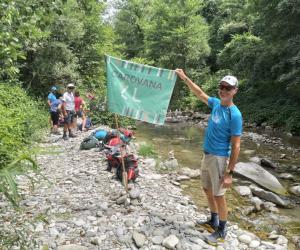
The National Park is an ideal place for hiking: a good network of trails, a hiking map now in its 5th edition, and numerous publications dedicated to hikers. The Park is also crossed by the Alta Via dei Parchi, a long route that connects the protected Apennine areas of the Emilia-Romagna Region and that locally coincides with the Sentiero delle Foreste Sacre.
In this framework, the suggestion of 11 three-day routes (two overnight) connecting shelters is something new: not only shelters, but also tourist farms, inns and old farmsteads that will offer the best of rural hospitality, immersed in the local tradition and in a territory rich in history and nature, certain of a warm welcome upon arrival at the facilities involved.
The weather events of last winter have caused a difficult situation for some paths in the Park. Since the practicability of all paths has not been restored, it is recommended to check the state of the paths related to the rings that you intend to travel. Consult the page on the state of practicability of the trails or contact the tourist office of the Park at the number 0575/503029 (Monday to Friday from 9 to 13 hrs).
THE RINGS “FROM SHELTER TO SHELTER”
See the Introduction Sheet (PDF) and details for each proposed ring:
1 • ACQUACHETA AND ALTO TRAMAZZO: Ring card 1 (PDF) - gps ring track 1 (RAR)
2 • ANCIENT PATHS ON BIDENTE DELLE CELLE: Ring card 2 (PDF) - ring track 2 (RAR)
3 • A RING IN THE HEART OF THE PARK: Ring Card 3 (PDF) - ring track 3 (RAR)
4 • THE VIA ROMEA AND THE ARCHIANO VALLEY: Ring Card 4 (PDF) - ring track 4 (RAR)
5 • MOUNT FALTERONA AND THE CAMPIGNA FOREST: Ring Card 5 (PDF) - ring track 5 (RAR)
6 • THE LANDS OF MONKS AND OF THE GRAND DUKE: Ring Card 6 (PDF) - ring track 6 (RAR)
7 • THE THOUSAND YEAR FOREST OF CAMALDOLI: Ring Card 7 (PDF) - ring track 7 (RAR)
8 • VERNA AND VALLESANTA: Ring Card 8 (PDF) - ring track 8 (RAR)
9 • ACQUACHETA AND ALTO MONTONE: Ring Card 9 (PDF) - ring track 9 (RAR)
10 • WILD VALLEYS BETWEEN RABBI AND MONTONE: Ring Card 10 (PDF) - ring track 10 (RAR)
11 • SOLITARY PLATEAUS IN VALLE DEL BIDENTE: Ring Card 11 (PDF) - ring track 11 (RAR)
> A web map is available online, on which it is possible to view the "From Shelter to Shelter" rings. The PNFC trekking mapp is also available, an App dedicated for hiking enthusiasts to "navigate" the paths of the Park even in offline mode, useful if you decide to take one of the rings.
> A box set is also available, collecting all the cards of the proposed rings, and a passport dedicated to the project, which can be used by those who decide to follow the recommended itineraries. As for a real passport, it will be possible to insert your personal data and request a stamp from the structures belonging to the project, which will offer a special treatment and care of the guests during their stay. It is possible to request the hiker's box and passport directly at the facilities involved or at the offices and information structures of the National Park.
For further information: 0575/503029 – promozione@parcoforestecasentinesi.it




 Integra Solutions